Neolithic Revelation: Vast 'Sacred Boundary' Redraws Map of Ancient Stonehenge Landscape
SALISBURY PLAIN, UK – A monumental discovery near Stonehenge has fundamentally reshaped archaeological understanding of Neolithic Britain, with researchers confirming the existence of a vast, 4,500-year-old circle of colossal shafts that once delineated a sacred boundary around the ancient settlement of Durrington Walls and Woodhenge. This awe-inspiring prehistoric structure, identified as the largest of its kind in Britain, suggests a level of societal organization and cosmological belief far more complex than previously imagined, offering a profound new perspective on the people who built the iconic stone circle.
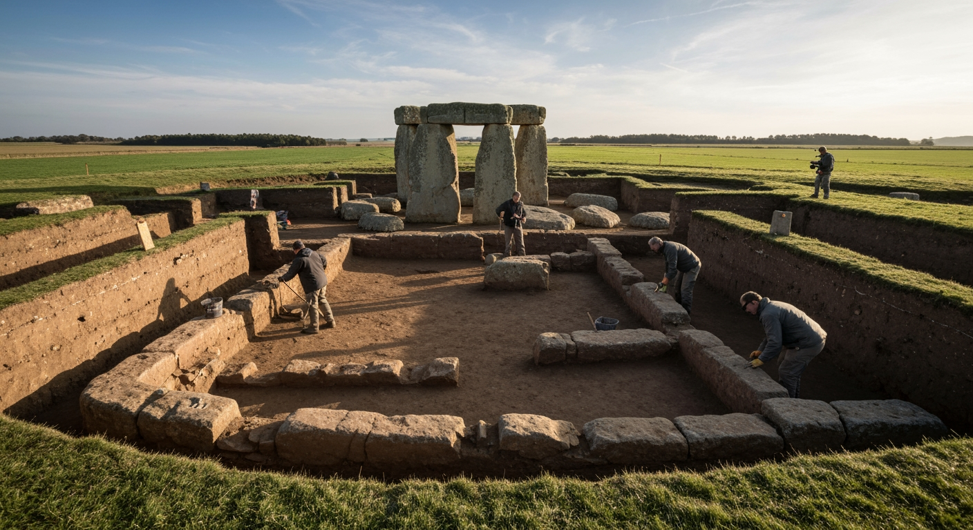
For decades, the Stonehenge landscape has been a focus of intense archaeological scrutiny, yet the recent findings underscore how much remains hidden beneath the surface. What was initially identified in 2020 as a series of enigmatic subterranean anomalies has now been definitively confirmed as a human-made construction, thanks to cutting-edge scientific techniques. This circular arrangement of more than 20 pits, each up to 10 meters in diameter and 5 meters deep, forms a perimeter stretching over 2 kilometers (1.2 miles), enclosing an area of more than three square kilometers. Its sheer scale and precise alignment speak to an extraordinary feat of engineering and communal effort by Neolithic communities.
Unveiling a Subterranean Marvel
The presence of these colossal pits was first hinted at in 2020, but skepticism lingered regarding their origin, with some experts suggesting they could be natural geological formations. However, a multidisciplinary research effort, involving institutions from across the UK, has now provided conclusive evidence of their human construction and purpose. Utilizing a combination of advanced geophysical techniques—including electrical resistivity tomography, ground-penetrating radar, and magnetic imaging—archaeologists were able to map the subterranean features without extensive excavation.
Further investigations involved borehole coring, sediment analysis, geochemistry, and revolutionary environmental DNA (sedaDNA) analysis. Crucially, Optically Stimulated Luminescence (OSL) dating confirmed that the pits were dug in the Late Neolithic period, approximately 4,500 years ago (around 2480 BC), making them contemporary with the construction of Durrington Walls. The soil samples revealed consistent layered infills, a pattern inconsistent with natural formation, solidifying the conclusion that these were intentionally engineered features. Professor Vincent Gaffney from the University of Bradford, who led much of the analysis, emphasized that these features were "not simply dug and abandoned" but were part of a "structured, monumental landscape."
The Sacred Enclosure: A Barrier to the Beyond
The primary interpretation for the Durrington pit circle is that it functioned as a "sacred boundary" or precinct. This massive enclosure effectively cordon off the ceremonial activities occurring at Durrington Walls and Woodhenge, two significant Neolithic sites located at its center. Archaeologists propose that this boundary might have guided individuals towards a consecrated area or, conversely, served as a warning to deter entry into a ritually significant space.
Unlike Stonehenge, which is famously aligned with the solstices and the passage of time, the Durrington pit circle appears to represent a different form of cosmological expression. Professor Gaffney noted that the circular shape itself suggests "a huge cosmological statement and the need to inscribe it into the earth itself." This intricate connection to the natural world and celestial events is a recurring theme in Neolithic monument building. Some researchers, including Professor Gaffney, have even speculated that the immense depth of the pits — some over 5 meters — might have been an attempt by the ancient inhabitants to forge a connection with the underworld. This profound engagement with both the heavens and the earth illustrates a holistic worldview deeply embedded in the daily and ritual lives of these early British communities.
An Unprecedented Feat of Neolithic Engineering
The sheer scale of the Durrington pit circle speaks volumes about the capabilities of its builders. Digging dozens of pits, each 10 meters wide and 5 meters deep, into the chalky landscape would have demanded an extraordinary level of planning, coordination, and labor using only primitive tools made of stone, wood, and bone. The precise, regular spacing of these features across such a vast area has led archaeologists to suggest that the Neolithic people must have employed some form of counting or tally system to accurately position the pits over long distances, marking an early example of sophisticated spatial awareness and numerical understanding.
This monumental undertaking highlights a highly organized society capable of mobilizing large numbers of people for a common, religiously motivated purpose. It suggests that the communities responsible for Stonehenge were part of a wider, integrated cultural landscape, where major construction projects were meticulously planned and executed. The Durrington Walls, often referred to as a "superhenge," served as a significant settlement and ceremonial site, likely hosting thousands of people at its peak. The pit circle would have physically and symbolically encompassed this vibrant hub, reinforcing its special status within the wider sacred geography.
Stonehenge's Expanding World
The discovery of the Durrington pit circle adds another layer of complexity to the already rich archaeological tapestry of the Stonehenge World Heritage Site. While the iconic stone circle remains a focal point, this new evidence confirms that it was part of a much grander, interconnected ritual landscape. It predates the main stone phase of Stonehenge and is contemporary with Durrington Walls, demonstrating that the monumental building efforts were not isolated but part of a sustained cultural tradition spanning centuries.
The previously known Stonehenge Cursus, a linear earthwork nearly 3 kilometers long and dating back even earlier (around 3630-3375 BCE), also illustrates the ancient inhabitants' propensity for creating large-scale boundaries and processional avenues. Although significantly older, the Cursus's western end lies close to the edge of the newly discovered pit circle, hinting at a long-term cultural memory and continuous interaction with the landscape over millennia. The Durrington pit circle provides a crucial missing piece in understanding the full scope of Neolithic activity, shifting perceptions from a singular focus on Stonehenge to a broader, more intricate network of sacred sites and monumental structures.
Conclusion
The confirmation of the Durrington pit circle marks a pivotal moment in the study of prehistoric Britain. It not only reveals the largest known prehistoric structure in the country but also offers unparalleled insights into the intricate belief systems, advanced organizational capabilities, and deep cosmological understanding of the Neolithic people. The "sacred boundary" surrounding Durrington Walls and Woodhenge demonstrates a society that actively inscribed its spiritual and social structures into the very earth, creating a landscape imbued with profound meaning. This discovery continues to unravel the mysteries of Stonehenge and its creators, reminding us that even in the most studied archaeological sites, the past holds many more secrets waiting to be unearthed.
Related Articles


Google's "Debug" Project Aims to Combat Disease with Millions of Mosquitoes
In an unconventional yet scientifically grounded endeavor, Alphabet Inc.'s life sciences subsidiary, Verily, is seeking to deploy millions of lab-reared mosquitoes across the United States. This initiative, known as the...


Bacteria Rewrite the Genetic Rulebook, Challenging Fundamental Principles of Life
For decades, the "Central Dogma" of molecular biology has stood as a cornerstone of our understanding of life, dictating that genetic information flows strictly from DNA to RNA to protein. Complementing this, the...


International Aid Cuts Exacerbate Ebola Crisis in Democratic Republic of Congo
Bunia, Democratic Republic of Congo – The Democratic Republic of Congo (DRC) finds itself grappling with its 17th Ebola outbreak, a deadly resurgence of the Bundibugyo strain that is rapidly spreading across its eastern...